


TSX-V: VO Last: 0.07 Change: 0.00 | OTCQB: KVLQF Last: 0.05 Change: 0.00
TSX-V: VO     Last: 0.07     Change: 0.00
OTCQB: KVLQF     Last: 0.05     Change: 0.00

Vancouver, B.C. ValOre Metals Corp. (TSXV: VO) ("ValOre") today announced initial rhodium (Rh) assay results for 51 historical, pulverized drill core samples (pulps) from the Pedra Branca Platinum Group Elements and Gold (PGE+Au) project in northeastern Brazil. This is the first-time rhodium has been assayed in drill core at Pedra Branca.

Key Point Summary:

  • Rhodium is a rare and valuable platinum group metal. The spot price of which has risen dramatically over the past 18 months from below US$4,000 per ounce in mid-2019 to the current price of US$11,500;
  • Rhodium mineralization has not been previously documented in drill core assays from Pedra Branca;
  • A strong correlation was noted between 2PGE+Au grade (palladium + platinum + gold) and rhodium grade, with the 5 highest-grade 2PGE+Au pulps exhibiting 4 of the highest Rh assay values;
  • The Esbarro deposit returned the best results, with 6 of 8 pulps over the detection limit, including the highest-grade assay of 1.44 grams Rh/tonne, and the highest average grade (0.35 g Rh/t);
  • 21 of the 51 pulps (41%) collected from five deposit areas making up the global NI 43-101 2PGE+Au inferred resource returned rhodium values over detection limit (0.01 g Rh/t).

ValOre’s Chairman and CEO, Jim Paterson stated: “Rhodium was previously undocumented in drilling related data at Pedra Branca; however, with these results we can see the correlation between the higher grades of palladium, platinum and rhodium in drill core and our team is excited to utilize this knowledge to help us in the exploration and discovery process on a regional scale.”

Fifty-one (51) historical Pedra Branca drill core pulp samples were submitted for rhodium assay at SGS Geosol, Minas Gerais. Batches of approximately 10 pulps from each of the existing five NI 43-101 PGE+Au deposits were selected on the following basis: a range of 2PGE+Au grades (from >2 to >44 g/t) and intercept depths (from near surface to >86m) to assess trends in rhodium distribution. A strong positive correlation of Rh grade to 2PGE+Au grade was evident, with the 5 highest-grade 2PGE+Au samples returning 4 of the highest Rh values. There was no observable trend in Rh grade distribution based on drill intercept depth.

The Esbarro deposit (394,000oz at a grade of 1.23 g 2PGE+Au/t) returned the best results, with 6 of 8 pulps assaying greater than detection limits, the highest-grade Rh assay (1.44 g Rh/t), and the highest average grade (0.35 g Rh/t). The Cedro deposit (151,000oz at a grade of 1.10 g 2PGE+Au/t) performed second-best, with 6 of 11 pulps assaying over detection, and the Curiu (100,000 oz @ 1.93 g 2PGE+Au/t) and Trapia (219,000 oz @ 1.11 g 2PGE+Au/t) deposits returned 4 of 8 and 4 of 12 pulps over detection, respectively. The Santo Amaro deposit (203,000oz at a grade of 1.19 g 2PGE+Au/t) returned no assays over Rh detection limit.

Rhodium assay results (SGS Geosol, Minas Gerais) from historical Pedra Branca drill core pulps are summarized in the following table:

Deposit Drill Hole Sample Depth From (m) Depth To (m) Historical Pd+Pt+Au (g/t) Rh (g/t)
Esbarro DD04ES35 90643 5.60 6.10 44.24 1.44
DD03ES15 89715 33.00 34.00 6.01 0.39
DD03ES31 90544 46.60 48.07 7.68 0.34
DD99ES05 89210 49.46 50.30 10.39 0.31
DD03ES11 89486 29.24 30.11 2.78 0.24
DD04ES35 90644 6.10 8.10 10.16 0.04
DD03ES21 90071 2.30 4.00 3.34 <0.01
DD03ES31 90541 43.00 44.90 2.16 <0.01
Cedro DD10CD86 87290 42.41 43.38 15.75 1.27
DD10CD89 87354 25.30 26.00 20.12 0.87
DD04CD18 91595 24.21 25.09 2.64 0.07
DD01CD04 90996 22.14 23.00 11.16 0.05
DD01CD03 90971 54.00 56.00 2.67 0.01
DD01CD05 91071 83.40 83.90 9.32 <0.01
DD10CD89 87345 14.30 16.00 5.39 <0.01
DD10CD79 87203 21.60 23.60 4.87 <0.01
DD01CD05 91082 95.41 96.64 3.29 <0.01
DD01CD05 91073 84.90 86.28 2.31 <0.01
Trapia DD09TU09 86012 42.81 43.53 5.76 0.27
DD04TU04 92565 85.57 86.50 3.25 0.16
DD01TW10 92891 42.46 43.46 3.17 0.04
DD09TW16 86054 36.29 36.79 7.69 0.01
DD99TW03 92779 19.81 20.39 5.56 <0.01
DD01TU03 92631 116.45 117.23 4.41 <0.01
DD99TW01 92678 11.45 12.42 3.30 <0.01
DD99TW07 92832 35.35 37.00 3.11 <0.01
DD07TW12 82405 14.65 15.31 2.81 <0.01
DD01TU02 92482 84.23 85.57 2.71 <0.01
DD01TU02 92481 82.79 84.23 2.25 <0.01
DD99TW04 92734 51.43 52.73 2.06 <0.01
Curiu DD04CU16 93313 1.74 3.00 7.89 0.17
DD03CU13 93207 7.79 9.19 20.45 0.08
DD03CU10 93122 67.40 68.00 3.35 0.03
DD04CU15 93283 1.25 3.11 3.63 0.02
DD03CU12 93180 38.33 39.33 6.90 <0.01
DD03CU10 93124 69.53 70.24 4.14 <0.01
DD03CU12 93186 44.88 45.81 3.80 <0.01
DD03CU11 93134 19.00 21.00 2.54 <0.01
Santo Amaro DD02SA02 93385 26.70 27.86 18.02 <0.01
DD04SA08 93532 109.75 110.25 8.66 <0.01
DD02SA02 93386 27.86 29.70 6.64 <0.01
DD02SA02 93393 39.00 40.40 3.80 <0.01
DD04SA08 93544 132.00 133.20 3.66 <0.01
DD02SA06 93601 55.00 55.58 2.18 <0.01
DD02SA02 93387 29.70 31.00 2.13 <0.01
DD02SA02 93433 87.65 89.15 2.05 <0.01

Further supporting ValOre’s initial review of Rh at Pedra Branca is an independent petrographic and x-ray diffraction (XRD) study conducted by Pathor Geological Consulting Ltd. at the University of Western Ontario in September, 2019. Pathor’s research identified As-Rh-bearing mineral inclusions and Bi-Pd tellurides occurring as anhedral or stringy inclusions within rims and cores of chromite, pyrite, and pentlandite (Banerjee and Botor, 2019).

While Rh in drill core or in soils has not been previously analyzed at Pedra Branca, there are some historical rock assay datasets that reported rhodium values. The historical Rh-in-rock data exhibits the positive correlation to high-grade 2PGE+Au rock samples, as illustrated in Figure 1.

Figure 1: Rhodium-in-Rock Sampling Data in the Central Pedra Branca PGE+Au District
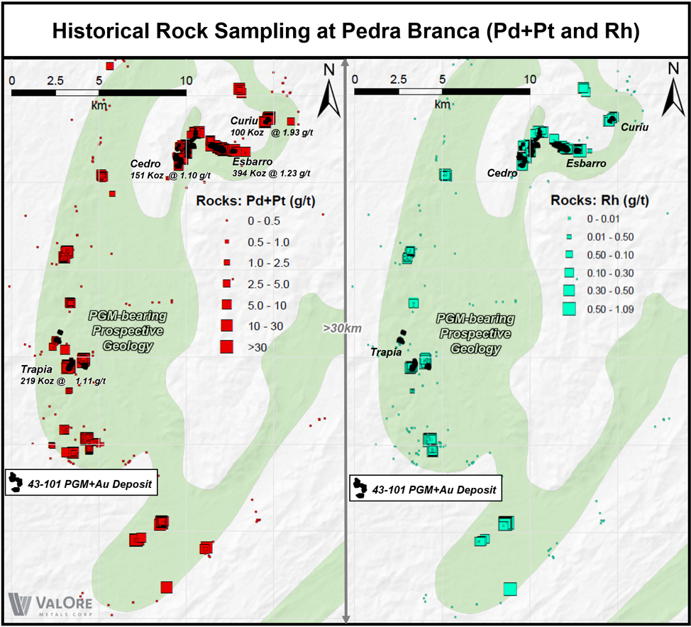
Figure 1

About Rhodium

Rhodium is the rarest of the platinum group metals, only occurring up to one part per 200 million in the Earth's crust. The main use for rhodium is in catalytic converters designed to clean vehicle emissions.  Due to its brilliance and resistance to oxidation, it is also used as a finish for jewelry, LCD monitors, and mirrors. In the chemical industry it is used in the production of nitric acid, acetic acid and hydrogenation reactions. Rhodium is found in platinum and nickel ores together with the other PGEs. South Africa is the world’s largest producer of rhodium (~80%) followed by Russia (~10%), Zimbabwe (~4%), Canada and the U.S.A.

The technical information in this news release has been prepared in accordance with Canadian regulatory requirements as set out in NI 43-101 and reviewed and approved by Colin Smith, P.Geo., New Project Review, ValOre Metals Corp.

Historical Pedra Branca drill core pulps were collected from the secured core logging and storage facility located in Capitão Mór, Ceará, Brazil. Selected pulp samples were sent with an ensured chain of custody to SGS Geosol, Vespasiano, Minas Gerais (Brazil) for analysis, which is accredited mineral analysis laboratory. All pulp samples were analyzed for Rh content using standard 50g Fire Assay Atomic Absorption ICP-MS. Certified PGE ore reference standards, blanks and field duplicates were inserted as a part of ValOre’s quality control/quality assurance program (QA/QC).  No QA/QC issues were noted with the results reported herein.

Neither the TSX Venture Exchange nor its Regulation Services Provider (as that term is defined in the policies of the TSX Venture Exchange) accepts responsibility for the adequacy or accuracy of this release.

Please visit ValOre’s website to view an updated corporate presentation and Pedra Branca project summary: http://www.valoremetals.com/investors/presentations-downloads/

About ValOre Metals Corp.

ValOre Metals Corp. (TSXV: VO) is a Canadian company with a portfolio of high‐quality exploration projects. ValOre’s team aims to deploy capital and knowledge on projects which benefit from substantial prior investment by previous owners, existence of high-value mineralization on a large scale, and the possibility of adding tangible value through exploration, process improvement, and innovation.

In May 2019, ValOre announced the acquisition of the Pedra Branca Platinum Group Elements (PGE) property, in Brazil, to bolster its existing Angilak uranium, Genesis/Hatchet uranium and Baffin gold projects in Canada.

The Pedra Branca PGE Project comprises 38 exploration licenses covering a total area of 38,940 hectares (96,223 acres) in northeastern Brazil. At Pedra Branca, 5 distinct PGE+Au deposit areas host, in aggregate, a NI 43-101 Inferred Resource of 1,067,000 ounces 2PGE+Gold (Palladium, Platinum and Gold; Pd, Pt+Au) contained in 27.2 million tonnes (“Mt”) grading 1.22 grams 2PGE+Gold per tonne (“g 2PGE+Au/t”) (see ValOre’s July 23, 2019 news release). PGE mineralization outcrops at surface and all of the inferred resources are potentially open pittable.

Comprehensive exploration programs have demonstrated the "District Scale" potential of ValOre’s 89,852-hectare Angilak Property in Nunavut Territory, Canada that hosts the Lac 50 Trend having a NI 43‐101 Inferred Resource of 2,831,000 tonnes grading 0.69% U3O8, totaling 43.3 million pounds U3O8. ValOre's. For disclosure related to the inferred resource for the Lac 50 Trend uranium deposits, please refer to ValOre's news release of March 1, 2013.

ValOre’s team has forged strong relationships with sophisticated resource sector investors and partner Nunavut Tunngavik Inc. (NTI) on both the Angilak and Baffin Gold Properties. ValOre was the first company to sign a comprehensive agreement to explore for uranium on Inuit Owned Lands in Nunavut Territory and is committed to building shareholder value while adhering to high levels of environmental and safety standards and proactive local community engagement.

On behalf of the Board of Directors,

"Jim Paterson"

James R. Paterson, Chairman and CEO

ValOre Metals Corp.

For further information about, ValOre Metals Corp. or this news release, please visit our website at www.valoremetals.com or contact Investor Relations toll free at 1.888.331.2269, at 604.646.4527, or by email at [email protected] .

ValOre Metals Corp. is a proud member of Discovery Group. For more information please visit: www.discoverygroup.ca

Neither the TSX Venture Exchange nor its Regulation Services Provider (as that term is defined in the policies of the TSX Venture Exchange) accepts responsibility for the adequacy or accuracy of this release.

This news release contains “forward-looking statements” within the meaning of applicable securities laws. Although ValOre believes that the expectations reflected in its forward-looking statements are reasonable, such statements have been based on factors and assumptions concerning future events that may prove to be inaccurate. These factors and assumptions are based upon currently available information to ValOre. Such statements are subject to known and unknown risks, uncertainties and other factors that could influence actual results or events and cause actual results or events to differ materially from those stated, anticipated or implied in the forward-looking statements. A number of important factors including those set forth in other public filings could cause actual outcomes and results to differ materially from those expressed in these forward-looking statements. Factors that could cause the actual results to differ materially from those in forward-looking statements include the future operations of the Company and economic factors. Readers are cautioned to not place undue reliance on forward-looking statements. The statements in this press release are made as of the date of this release and, except as required by applicable law, ValOre does not undertake any obligation to publicly update or to revise any of the included forward-looking statements, whether as a result of new information, future events or otherwise. ValOre undertakes no obligation to comment on analyses, expectations or statements made by third parties in respect of ValOre, or its financial or operating results or (as applicable), their securities.
Vancouver, B.C. ValOre Metals Corp. (TSXV: VO) (“ValOre”) today announced receipt of grab sample assay results from the newly-defined “C04” exploration target, as well as high-quality 3D magnetic inversion models for all five National Instrument 43-101 (“NI 43-101”) deposit areas at the Pedra Branca project located in Brazil.

Key Point Summary:

  • Exploration targeting methodology successfully implemented;
  • Database-wide review of recently reprocessed magnetic anomalies (Anglo American’s airborne survey, 2013) combined with priority chromitite and ultramafic targets from satellite imagery (WorldView data, 2019);
  • Field identification of chromitite mineralization and other coarse-grained cumulate ultramafic rocks at the C04 anomaly;
  • Four of four grab samples from C04 returned compelling platinum group metals and gold (“PGM+Gold”) assay results;
  • ValOre crew now identifying optimal drill hole locations for a 2020 resource expansion and exploration drilling program;
  • At Pedra Branca, the five distinct PGM deposit areas hosting the NI 43-101 inferred resource estimate are road or dirt track accessible. The project area is a 4-hour drive on paved highways from the city of Fortaleza.

ValOre’s Chairman and CEO, Jim Paterson commented: “ValOre’s technical team has made tremendous progress in organizing, reviewing, and understanding a literal ‘treasure trove’ of data generated at Pedra Branca by previous exploration groups. It is very exciting to recognize that, in the case of C04, we have an exploration methodology that works so efficiently and effectively. We believe Pedra Branca is a target-rich environment which hosts a ‘discovery pipeline’ with the potential to add significant value for our shareholders.”

Four grab samples were submitted to SGS Canada for analysis, and all returned compelling PGM+Gold results of up to 7.945 g/t. Assay results for all submitted samples are summarized in the following table:

Sample Au (ppb) Pt (ppb) Pd (ppb) PGM+Gold (ppb) PGM+Gold (g/t)
B-C4-11-A 23 7616 306 7945 7.945
B-C4-11-B 13 2039 338 2390 2.390
B-C4-11-C 52 2125 142 2319 2.319
B-C4-11-D 13 2722 301 3036 3.036

Summary of assay results from four submitted grab samples at the C04 exploration target, Pedra Branca project (SGS Canada Inc.)

C04 was the inaugural test case of pure greenfields targeting for ValOre at Pedra Branca, involving investigations of discrete reduced to pole (RTP) magnetic anomalies, derived from re-processing of Anglo American’s airborne magnetic survey, combined with targeting priorityclasses of spectral chromitite and ultramafics, which were derived from 2019 WorldView satellite data. This led to the field identification of chromitite mineralization and other coarse-grained cumulate ultramafic rocks at the C04 anomaly located approximately 5 km north of the Esbarro Deposit (2019 NI 43-101 resource of 394 Koz PGM+Gold; see ValOre news release, July 23, 2019) in rolling brush-covered terrain. The four samples were collected at surface from the center of the C04 magnetic anomaly which coincided with the multi-class WorldView spectral chromitite targets.

ValOre’s identification of C04 is significant, as there were no mapped ultramafic rocks, and no historical soil, rock or stream sediment data related to this target area in the existing database. The chromitite discovery was achieved solely by using ValOre’s re-processed RTP aeromagnetic and WorldView spectral data, thus successfully confirming ValOre’s exploration methodology. ValOre geologists encountered evidence of historical exploration at C04 that predates the existing database: a 2m x 2m x 4m pit, and adjacent trench. It is likely that this historical work was performed by Gencor in the late 1980s, and never incorporated into the existing database. Given the encouraging assay results returned from C04, it will be added to the list of exploration targets selected for 3D magnetic inversion modelling and potential subsequent drill testing.

This sets the stage for the follow-up of numerous other pure greenfields targets in the region, with significant implications for expanding the exploration and development potential of Pedra Branca. ValOre is acquiring WorldView data for 643 km2 of highly-prospective terrain – a dataset that is now proven effective at PGM+Gold discovery when paired with the recently re-processed 652 km2 airborne magnetic data.

Further, ValOre broadened its geophysical dataset by procuring and re-processing raw data from 39 historical ground magnetics surveys. This includes multiple target areas outside of the airborne block, and facilitates the merging of airborne and ground magnetic datasets to yield a highly-refined geophysical targeting product.

ValOre has also just received detailed 3D magnetic inversion models for all five NI 43-101 PGM+Gold deposit areas. High-quality merged airborne and ground magnetic data facilitated modeling and interpretation to a 10m x 10m x 10m cell size, and multiple un-drilled resource expansion targets have been identified at all five deposits. Fifteen additional high-priority exploration targets (external to the NI 43-101 resource) have been selected and submitted for detailed 3D magnetic inversion modelling.

A ValOre crew is currently on site with a goal of identifying optimal drill hole locations for a 2020 resource expansion and exploration drilling program. Details on the drill program size and budget will be announced in Q1 2020.

The Pedra Branca project is a Platinum Group Metals (“PGM”) District located in northeastern Brazil covering a total area of 38,940 hectares (96,223 acres) that includes 38 exploration licenses. The independent NI 43-101 resource estimate (See ValOre news release July 23, 2019) is comprised of 5 distinct deposit areas which host, in aggregate, an inferred resource of 1,067,000 ounces PGM+Gold (Palladium, Platinum and Gold; Pd, Pt+Au) in 27.2 million tonnes (“Mt”) grading 1.22 grams PGM+Gold per tonne (“g PGM+Au/t”). PGM mineralization outcrops at surface and all of the known inferred resources are potentially mineable by open pit methods.

The technical information in this news release has been prepared in accordance with Canadian regulatory requirements set out in NI 43-101 and reviewed and approved by Colin Smith, P.Geo., who oversees New Project Review for ValOre.

Grab samples are collected from field sites with coordinate data captured by handheld GPS and subsequently stored in a secure ValOre facility in Capitão Mór, Ceara, Brazil. The samples are thereafter sent with an ensured chain of custody to SGS Canada Inc. in Lakefield, Ontario for analysis, which is accredited mineral analysis laboratory. All samples are analyzed for PGM+Gold (Pd, Pt, Rh, Au) content using standard 50g Fire Assay and ICP-AES techniques. If Pt and/or Pd is over 1%, the sample is analyzed for Rh using NiS Fire Assay-ICP-MS techniques. Cr values that exceed 5% are redirected to ore grade pyrosulfate fusion and XRF techniques. Certified PGM ore reference standards, blanks and field duplicates are inserted as a part of ValOre’s quality control/quality assurance program (QAQC).  No QAQC issues were noted with the results reported herein.

Neither the TSX Venture Exchange nor its Regulation Services Provider (as that term is defined in the policies of the TSX Venture Exchange) accepts responsibility for the adequacy or accuracy of this release.

Please visit ValOre’s website to view an updated corporate presentation and project summary: http://www.valoremetals.com/investors/presentations-downloads/

About ValOre Metals Corp.

ValOre Metals Corp. (TSXV: VO) is a Vancouver based company with a portfolio of high‐quality exploration projects.  ValOre’s team aims to deploy capital and knowledge on projects which benefit from substantial prior investment by previous owners, existence of high-value mineralization on a large scale, and the possibility of adding tangible value through exploration, process improvement, and innovation.

ValOre recently acquired an exciting PGM property, Pedra Branca, in Brazil, to bolster its existing Angilak uranium, Genesis/Hatchet uranium and Baffin gold projects in Canada.

Pedra Branca project is a PGM District located in northeastern Brazil that comprises 38 exploration licenses covering a total area of 38,940 hectares (96,223 acres). At Pedra Branca, five distinct PGM deposit areas host, in aggregate, a NI 43-101 inferred resource estimate of 1,067,000 ounces PGM+Gold (Palladium, Platinum and Gold; Pd, Pt+Au) in 27.2 million tonnes (“Mt”) grading 1.22 grams PGM+Gold per tonne (“g PGM+Au/t”) (see ValOre news release July 23, 2019). PGM mineralization outcrops at surface and all of the inferred resources are potentially mineable by open pit.

ValOre’s 89,852-hectare Angilak Property in Nunavut Territory, hosts the Lac 50 Trend with a NI 43‐101 Inferred Resource of 2,831,000 tonnes grading 0.69% U3O8, totaling 43.3 million pounds U3O8. ValOre's comprehensive exploration programs have demonstrated the “District Scale” potential of the Angilak Property. For disclosure related to the inferred resource for the Lac 50 Trend uranium deposits, please refer to ValOre's news release of March 1, 2013.

ValOre’s team has forged strong relationships with sophisticated resource sector investors and partner Nunavut Tunngavik Inc. (NTI) on both the Angilak and Baffin Gold Properties. ValOre was the first company to sign a comprehensive agreement to explore for uranium on Inuit Owned Lands in Nunavut Territory, Canada and is committed to building shareholder value while adhering to high levels of environmental and safety standards and proactive local community engagement.

On behalf of the Board of Directors,

“Jim Paterson”

James R. Paterson, Chairman and CEO

ValOre Metals Corp.

For further information about, ValOre Metals Corp. or this news release, please visit our website at www.valoremetals.com  or contact Investor Relations toll free at 1.888.331.2269, at 604.646.4527, or by email at [email protected] .

ValOre Metals Corp. is a proud member of Discovery Group. For more information please visit: www.discoverygroup.ca.

Cautionary Statement on Forward-Looking Statements

This news release contains “forward-looking statements” within the meaning of applicable securities laws. Although ValOre believes that the expectations reflected in its forward-looking statements are reasonable, such statements have been based on factors and assumptions concerning future events that may prove to be inaccurate. These factors and assumptions are based upon currently available information to ValOre. Such statements are subject to known and unknown risks, uncertainties and other factors that could influence actual results or events and cause actual results or events to differ materially from those stated, anticipated or implied in the forward-looking statements. A number of important factors including those set forth in other public filings could cause actual outcomes and results to differ materially from those expressed in these forward-looking statements. Factors that could cause the actual results to differ materially from those in forward-looking statements include the future operations of the Company and economic factors. Readers are cautioned to not place undue reliance on forward-looking statements. The statements in this press release are made as of the date of this release and, except as required by applicable law, ValOre does not undertake any obligation to publicly update or to revise any of the included forward-looking statements, whether as a result of new information, future events or otherwise. ValOre undertakes no obligation to comment on analyses, expectations or statements made by third parties in respect of ValOre, or its financial or operating results or (as applicable), their securities.

VANCOUVER, BC – ValOre Metals Corporation (TSX-V: VO) (“ValOre” or the “Company”) today announced results from the 2018 summer exploration program at the 100% owned Baffin Gold Property in Nunavut Territory, Canada. The Baffin Gold Property has one of the largest undeveloped greenstone-iron formation gold belts in Nunavut, totalling 405,083 ha and covering 160 km of the Foxe Fold Belt on central Baffin Island. Sampling results from the Company’s 2018 season have significantly expanded gold-in-till target areas, while new airborne geophysics has highlighted underlying geological settings and possible structural controls for mineralization over much of the Property.

 2018 Highlights:

  • Results from 438 till geochemical samples infilled the 2017 work and outlined three, kilometre-scale areas with anomalous gold in underexplored, prospective geology west of the high-grade Brent and Ridge occurrences;
  • Results from 31 rock samples confirmed high-grade gold at Durette, an area of complex folded Bravo Formation iron formation and metavolcanics;
  • Highlight grab rock samples from 2018 include:
    • 42% of rock samples taken in 2018 (13) assayed > 5g/t
    • 67.9 g/t Au – Durette  quartz-arsenopyrite vein
    • 46.4 g/t Au – Brent quartz-aresenopyrite vein
    • 29.2 g/t Au – Durette quartz-arsenopyrite vein;
  • 6,984 line kilometres of airborne horizontal gradient magnetics was flown on two grids. ValOre now has near-continuous geophysical coverage over 110 kilometres of strike on the Property.

“ValOre has defined several new, large scale  gold anomalies in till; the significance of these is enhanced by a greater understanding of the geological setting based on new airborne data collected in 2018,” stated ValOre President Jeff Ward. “We are excited to expand our efforts and methods to better define the many known gold targets and to make meaningful discoveries at other untested parts of the Baffin Property.”

West-Central Belt

ValOre’s 2017 exploration program evaluated a 68 kilometre-long central portion of the Baffin Gold Property. The program confirmed significant gold bearing zones and provided a better understanding of the varied host geological settings. As follow-up, the 2018 summer program focused on infilling geochemical datasets and having 110 kilometres of near-continuous airborne geophysical coverage in the central and western part of the property (West Central Belt). Results from the 2018 work have outlined two key target areas called Emily Lake and West Brent, where historic exploration was limited (see Figure 1).

Emily Lake

The Emily Lake target area is located within the West Central Belt approximately 15 kilometres west of the Brent occurrence. Till sampling in 2018 was designed to expand anomalous results returned from the 2017 Emily Lake test grid. Thirteen samples returned anomalous values above the 95th percentile at Emily Lake, including 27.79 ppb Au and 13.23 ppb Au. The 2018 results confirm an extensive gold-in-till anomaly covering approximately 12 square kilometres. Corroborating geophysical data similarly shows Emily Lake as an area with extensive bedrock folding and possible dilation zones, an ideal setting for gold emplacement.

South of Emily Lake, a six-kilometre-long east-west corridor with anomalous gold-in-till remains open along strike and may extend northeast to the new West Brent target area.

West Brent

The West Brent target area extends approximately four kilometres west of the high-grade Brent prospect area. Results from the 2018 till sampling outlined a broad gold-in-till signature extending west from the Brent showing that remains open to the north, south and east. Geophysics also shows a distinct jog in the Bravo Lake volcanics and iron formation that coincides with this geochemical anomaly. Thirteen samples in the West Brent area returned Au assays above the 75th percentile, with the highest results of 12.85 ppb Au, 7.74 ppb Au and 6.38 ppb Au.

2018 Till Geochemical Sampling

The 2018 summer program included the collection of 438 till geochemical samples in the West Central portion of the Property. The till program was designed to delineate anomalous trends identified in 2017 and repeat regional gold-in-till values from historic sampling. The 2018 grid covered 15 kilometres of prospective geology from east to west (see Figure 1), evaluating Bravo Lake formation rocks at Emily Lake eastward toward the Brent showing. Glacial till samples approximately 2 to 3 kilograms each were collected at 125 or 250 metre intervals along sample lines spaced 250 or 500 metres apart. The Au-CN44 cyanide extraction and ICP-MS analysis used in both 2017 and 2018 proved to be very effective at repeating and mapping historic geochemical and gold grain anomalies.

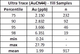
The 2018 till sampling infilled and expanded upon results from the 2017 survey.  Table 1 shows value ranges and anomalous thresholds for gold (ppb) from the combined 2017 and 2018 Baffin Gold Property data sets. 

Table 1.  2017-2018 Comparative Percentile Values

Tailings Expansion Area

2018 Airborne Magnetic Survey

Tundra Airborne Surveys Ltd. of St. Catharines, Ontario completed a 6,984 line kilometres fixed wing (horizontal gradient) aeromagnetic survey on the Baffin Gold Property in 2018. North south lines were flown at 200 metre spacing. The survey in-filled and extended existing airborne coverage (see Figure 2), with some overlap to help integrate historic data.

Data from the near continuous 110 kilometres of geophysical coverage on the Property will assist in mapping the gold-bearing Bravo Lake Formation, prospective structures, and help identify geological settings for numerous unexplained gold-in-till anomalies from historic work not yet followed-up.

Maps and images of the work performed in 2018 at the Baffin Gold Property available at:

http://valoremetals.com/_resources/news/ValOre-Baffin-Property-2018-Geophysics.jpg

http://valoremetals.com/_resources/news/ValOre-Baffin-Property-2018-Sampling.jpg

QA/QC

All till samples were sent to ALS Geochemistry (ALS) in Sudbury, Ontario for preparation and then to ALS in Vancouver, BC for final analysis. ALS Geochemistry meets all requirements of International Standards ISO/IEC 17025:2005 and ISO 9001:2015. All ALS hub laboratories are accredited to ISO/IEC 17025:2005 for specific analytical procedures. Till samples were analysed for gold using cyanide extraction (Au-CN44) with a 33-element four acid digest ICP-AES analysis (ME-ICP61). All rock samples were sent to ALS in Sudbury, Ontario for preparation and then to ALS in Vancouver, BC for final analysis. Rock samples were analyzed using ALS’s Fire Assay Fusion method (Au-AA23) with an AAS finish for gold, followed by a 33-element four acid digest ICP-AES analysis (ME-ICP61). QA/QC included ValOre field duplicates for till plus, internal lab standards, duplicates, re-assays, and blanks inserted by ALS. All QA/QC results for till and rock samples were within expectations.

Jeff Ward, P.Geo, President of ValOre and a Qualified Person under National Instrument 43-101 has reviewed and approved the technical information contained in this release. Exploration results by Commander and previous explorers reported herein and on maps are historic in nature and although not verified by ValOre, this work was carried out by knowledgeable explorers using acceptable industry practices at the time. 

About ValOre Metals Corporation

ValOre Metals Corp. (TSX‐V: VO) is a Vancouver based company with a portfolio of high‐quality uranium and precious metal exploration projects in Canada. In addition to the Baffin Gold Property, ValOre holds Canada's highest‐grade uranium resource outside of Saskatchewan. ValOre’s 89,852 hectare Angilak Property in Nunavut Territory, hosts the Lac 50 Trend with a NI 43‐101 Inferred Resource of 2,831,000 tonnes grading 0.69% U3O8, totaling 43.3 million pounds U3O8. ValOre's comprehensive exploration programs have demonstrated the "District Scale" potential of the Angilak Property. For disclosure related to the inferred resource for the Lac 50 Trend uranium deposits, please refer to ValOre's news release of March 1, 2013.

In Saskatchewan, ValOre holds a 100% interest in the 13,711 hectare Hatchet Lake Property and a 50% interest in the 131,412 hectare Genesis Property, both located northeast of the north‐eastern margin of the uranium‐producing Athabasca Basin.

ValOre’s team has forged strong relationships with sophisticated resource sector investors and partner Nunavut Tunngavik Inc. (NTI) on both the Angilak and Baffin Gold Properties. ValOre was the first company to sign a comprehensive agreement to explore for uranium on Inuit Owned Lands in Nunavut Territory, Canada and is committed to building shareholder value while adhering to high levels of environmental and safety standards and proactive local community engagement.
 

On behalf of the Board of Directors

"Jim Paterson"

James R. Paterson, Chairman and CEO

ValOre Metals Corporation
For further information about, ValOre Metals Corporation or this news release, please visit our website at www.valoremetals.com or contact Investor Relations toll free at 1.888.331.2269, at 604.646.4527, or by email at [email protected].

ValOre Metals Corporation is a member of the Discovery Group of Companies, for more information please visit: www.discoverygroup.ca

Neither the TSX Venture Exchange nor its Regulation Services Provider (as that term is defined in the policies of the TSX Venture Exchange) accepts responsibility for the adequacy or accuracy of this release.

Certain disclosures in this release constitute forward-looking statements that are subject to numerous risks, uncertainties and other factors relating to ValOre 's operations as a mineral exploration company that may cause future results to differ materially from those expressed or implied in such forward-looking statements, including risks as to the completion of the plans and projects. Readers are cautioned not to place undue reliance on forward-looking statements. Other than as required by applicable securities legislation, ValOre expressly disclaims any intention or obligation to update or revise any forward-looking statements whether as a result of new information, future events, or otherwise.

Vancouver, B.C. – ValOre Metals Corporation (TSX-V: VO) (“ValOre”) today announced the completion the 2018 summer exploration program at ValOre’s 100% owned Baffin Gold Property in Nunavut Territory, Canada. The 2018 program included a 7,038 line-kilometre aeromagnetic survey and the collection of 431 till and 31 rock geochemical samples. The Baffin Gold Property covers one of the largest undeveloped greenstone-iron formation gold belts in Nunavut, totalling 408,981.6 ha and covering 160 kilometres of the Foxe Fold Belt on central Baffin Island.

“With this new 2018 airborne data, and further till sampling in under-explored areas, we are excited to see how our knowledge from significant gold results from 2017 can be applied to the larger regional setting,” stated ValOre President Jeff Ward. “We are confident that ValOre’s first two Baffin Gold programs will upgrade current targets and begin to unlock the potential of this prolific gold belt.”

As follow-up to the 2017 program, ValOre’s 2018 summer program focussed on infilling current geophysical datasets and obtaining airborne geophysical coverage on lands not yet explored. The airborne survey was designed to extend known gold-bearing Bravo Lake Formation geology and find additional occurrences using new geophysical data over gold-in-till anomalies not yet followed-up. With this new survey, ValOre now has continuous airborne geophysical data covering 120 kilometres of the prospective Foxe Fold Belt. 

Last year, ValOre’s maiden exploration program focused on a 68 kilometre-long central portion of the large Baffin Gold Property. The program succeeded in confirming significant gold bearing zones and provided a better understanding of the varied host geological settings. The 2017 program reported numerous high-grade gold assays from banded iron formation and quartz veins, and seven new priority areas delineated by anomalous geochemical results in till (see October 25, 2017 news release).

During the month of July 2018, Tundra Airborne Surveys Ltd. (“Tundra”) of St. Catharines, Ontario completed a 7,038 line-kilometre, fixed wing (horizontal gradient) aeromagnetic survey on the Baffin Gold Property. The survey in-filled and extended existing geophysical grids, with some overlap to help integrate legacy data. Fixed wing aeromagnetic lines were flown at 200 metre spacing. Final deliverables from Tundra are expected by late September 2018.

During Tundra’s airborne survey operations, a four-person field crew collected 438 till and 31 rock geochemical samples. The till sampling program was designed to expand anomalous trends discovered in 2017 and repeat regional gold-in-till values from historic sampling. Line spacing was between 250 and 500 metres, or 125 metres in areas of interest. Sample spacing was between 125 and 250 metres. All samples will be sent to ALS Geochemistry (ALS) in Vancouver, BC for final analysis. Till samples will be submitted for Au-CN44 cyanide extraction and ME-ICP61 analysis. Rock samples will be analyzed using Au-AA23 fire assay methods with final ME-ICP61 analysis. ALS Geochemistry meets all requirements of International Standards ISO/IEC 17025:2005 and ISO 9001:2015.

Jeff Ward, P.Geo, President of ValOre and a Qualified Person under National Instrument 43-101 has reviewed and approved the technical information contained in this release.

About ValOre Metals Corporation

ValOre Metals Corporation (TSX-V: VO) is a Vancouver-based company with a portfolio of high-quality uranium and precious metal exploration projects in Canada. In addition to the new Baffin Gold Property, ValOre holds Canada’s highest-grade uranium resource outside of Saskatchewan. The Company’s flagship project, the 89,852 hectare Angilak Property in Nunavut Territory, hosts the Lac 50 Trend with a NI 43-101 Inferred Resource of 2,831,000 tonnes grading 0.69% U3O8, totaling 43.3 million pounds U3O8. ValOre’s comprehensive exploration programs continue to demonstrate the “District Scale” potential of the Angilak Property. For disclosure related to the inferred resource for the Lac 50 Trend uranium deposits, please refer to ValOre’s news release of March 1, 2013.

In Saskatchewan, ValOre holds a 100% interest in the 13,711 hectare Hatchet Lake Property adjacent to the north-eastern margin of the highly prolific uranium-producing Athabasca Basin. Compilation of results from previous exploration by Hathor Exploration Limited and Rio Tinto have identified multiple, priority unconformity-related basement targets at Hatchet Lake that were followed up in 2015.

ValOre also holds a 50% interest in the 131,412 hectare Genesis Property located northeast of Saskatchewan’s Athabasca Basin, with Roughrider Exploration Limited funding the current exploration program pursuant to an option to acquire up to an 85% interest in the property. This highly prospective project is located along the Wollaston-Mudjatik trend and extends 90 kilometres northeast from Wollaston Lake to the Manitoba border.

ValOre’s team of northern exploration specialists has forged strong relationships with sophisticated resource sector investors and partner Nunavut Tunngavik Inc. (NTI) on both the Angilak and Baffin Gold Properties. ValOre was the first company to sign a comprehensive agreement to explore for uranium on Inuit Owned Lands in Nunavut Territory, Canada and is committed to building shareholder value while adhering to high levels of environmental and safety standards and proactive local community engagement.
 

On behalf of the Board of Directors

"Jim Paterson"

James R. Paterson, Chairman and CEO

ValOre Metals Corporation

For further information about, ValOre Metals Corporation or this news release, please visit our website at www.valoremetals.com or contact Investor Relations toll free at 1.888.331.2269, at 604.646.4527, or by email at [email protected].

ValOre Metals Corporation is a member of the Discovery Group of Companies, for more information please visit: www.discoverygroup.ca .
 

Neither the TSX Venture Exchange nor its Regulation Services Provider (as that term is defined in the policies of the TSX Venture Exchange) accepts responsibility for the adequacy or accuracy of this release.

Certain disclosures in this release constitute forward-looking statements that are subject to numerous risks, uncertainties and other factors relating to ValOre 's operations as a mineral exploration company that may cause future results to differ materially from those expressed or implied in such forward-looking statements, including risks as to the completion of the plans and projects. Readers are cautioned not to place undue reliance on forward-looking statements. Other than as required by applicable securities legislation, ValOre expressly disclaims any intention or obligation to update or revise any forward-looking statements whether as a result of new information, future events, or otherwise.

VANCOUVER, BC – Kivalliq Energy Corporation (TSX-V: KIV) (“Kivalliq”) today announced results from  the 2017 summer exploration program at Kivalliq’s 100% owned, Baffin Gold Property in Nunavut Territory, Canada. The Baffin Gold Property is one of the largest undeveloped greenstone-iron formation gold belts in Nunavut, totalling 408,981.6 ha and covering 160 km of the Foxe Fold Belt on central Baffin Island. These results are the first step toward understanding and advancing significant gold-bearing zones and anomalies that occur in a variety of geological settings within the Baffin Gold Property.

 2017 Highlights:

  • Results from 424 rock samples confirmed high-grade gold in banded iron formation (BIF) and (intrusion?)-metasediment hosted quartz veins.  Highlight grab and channel sample assays include:
    • 268 g/t (7.8 oz/ton) Au – Malrok BIF grab sample
    • 211 g/t (6.1 oz/ton) Au over 0.5 m and 102.5 g/t (3.0 oz/ton) Au over 0.5 m – Kanosak quartz vein channel sample
    • 114.5 g/t  (3.3 oz/ton) and 96.2 g/t (2.8 oz/ton) Au – Brent quartz vein grab sample
    • 86.1 g/t (2.5 oz/ton) Au over 0.96 m, includes 193 g/t  (5.6 oz/ton) Au over 0.32 m –
      W Kanosak/Qim 4 BIF channel sample
    • 20% of rock samples taken in 2017 (85) were > 0.5 g/t Au
  • Results from 492 till geochemical samples identified a new 10 km long corridor of anomalous gold at south Kanosak, and further outlined seven anomalous areas warranting follow-up at Kanosak, Brent and Central Belt west.
  • Rock and new till geochemical results have extended the strike length of known gold occurrences at Brent, confirmed gold in BIF over 5 km and 6 km at west and north Kanosak, and expanded anomalies around historic gold in till results  
  • 65 km2 of high resolution airborne drone imagery flown in key target areas will be used to develop digital surface models and aid structural interpretation.

Maps and images of the work performed in 2017 at the Baffin Gold Property can be viewed at: http://www.kivalliqenergy.com/projects/baffin_gold/maps/

“We are excited that Kivalliq’s first summer on the Baffin Gold Property was able to confirm gold in a variety of geological settings in Bravo Lake Formation rocks across 68 km of strike length,” stated Kivalliq President Jeff Ward. “Furthermore, till sampling was able to discover a new corridor of elevated gold-in till and advance other historic anomalies, substantiating our belief in the untapped potential of this extremely prospective gold belt”.   

Kivalliq’s exploration efforts targeted gold in banded iron formation, and greenstone-metasediment hosted quartz veins through an initial program of prospecting, mapping, rock sampling and till geochemical surveys. The 2017 program succeeded in confirming gold settings, repeating geochemical trends and extending known occurrences in the Kanosak, Brent and west Central belt target areas.  In preparation for future drilling, upcoming work will concentrate on: understanding structural controls for gold, integrating drone imagery with existing datasets, follow-up of new gold anomalies and continued reconnaissance till sampling areas of deeper glacial cover.

Kanosak Target Area

The Kanosak Target area is located at the east end of the Baffin Gold Property. Two distinct gold mineralization styles are present: arsenopyrite bearing quartz veins hosted in clastic sediments (Kanosak, Kanosak south) and; sulphidized silicate-oxide iron formation (Qim 4, Qim 5).  Rock sampling at Kanosak confirmed the presence of high grade gold within quartz veins hosted by quartzites and micro-conglomerate. Highlights of 2017 repeat sampling of high grade Commander Resources channels include: 211 g/t Au over 0.5 m and 102.5 g/t Au over 0.5m. Vein distribution at Kanosak is strongly controlled by host lithologies with best vein development being restricted to brittle, coarse clastic beds.

Prospecting, rock sampling and till sampling was conducted along the south and southeast portion of the Kanosak area. Here, elevated gold in till over 500 m of strike length corresponds to a 2.5 km east-west belt of interbedded clastic rocks with quartz veining. In addition, a large till survey grid in the south Kanosak area has identified a 10 km long corridor of gold anomalies that runs sub-parallel to folded stratigraphy.  This anomalous gold in till trend and cursory mapping suggests the potential to discover new gold-bearing zones in unmapped BIF along the edges of gneissic domes.

A till sampling grid was located in the north-central Kanosak area to test six historic samples having  gold grains and situated on the axis and nose of a regional syncline. Results from the 2017 work corroborated these historic gold results with new geochemical anomalies in till and further sampling is warranted.

In the north and west Kanosak areas, samples taken along BIF confirmed gold occurrences along six km (Qim 5) and five km (Qim 4) of strike length respectively.  Iron formation corresponds directly with pronounced magnetic highs and is generally exposed as small, low outcrops and subcrops of sulphide and grunerite-silica rock. Twenty samples within BIF returned gold values greater than 1 g/t, with nine samples returning greater than 5 g/t Au. Channel samples taken by Kivalliq at the north end of Qim 4 repeated significant channel results in BIF taken by Commander Resources. This historic channel sample assayed 40.8 g/t Au over 0.96 m and was sampled again in detail to test specific lithologies within the BIF. The second set of results produced a weighted average of 86.14 g/t Au over the length of the detailed channel, with the upper massive grunerite quartz layer returning an impressive 193 g/t Au.

Brent Target

At Brent, quartz veins are oriented north-south and are best developed beside a zone of sub-vertical, east-west shearing within mafic rocks, at the contact with the host diorite-gabbro. The nature of the orientation of the contact between the mafic and gabbro is not known and five historic holes drilled along the trend did not resolve mineralization at surface. Historic grab sampling defined two trends of auriferous quartz veining hosted within a quartz diorite/altered gabbro, with the southern trend being most anomalous. Mineralization is comprised of massive clots of arsenopyrite within the veins and as disseminated arsenopyrite in the altered diorite adjacent to veins. Of the 33 rock samples collected in 2017, 11 returned values of greater than 1 g/t Au, with four samples returning very high grade gold values between 51.3 and 114.5 g/t Au.

A three km long till sampling grid was established this summer over the southern Brent trend in an attempt to tie together historic drilling, rock sampling, gold grains in till and the 2017 repeat results. Anomalous gold geochemistry was present on almost every 2017 till sample line, extending the Brent target zone to 2.5 km of strike length. 

West-Central Belt

Exploration in the West Central Belt focused on expanding historic isolated gold anomalies in lesser explored areas, and repeating gold values at Malrok.  Three of the four 2017 till sample grids verified historic geochemistry and gold grains reported from this complex folded segment of Bravo Lake formation, including a few outlier gold values in younger Piling Group rocks. The success of broad spaced till sampling in this part of the property indicates this will be an effective exploration tool in areas of less rock exposure and deeper glacial cover.   

The Malrok occurrence was visited primarily to review the geological setting of this advanced prospect. One repeat sample of upper Bravo Lake BIF returned 268 g/t Au and was the highest assay in 2017. The remaining samples at Malrok tested mainly lower Bravo stratigraphy and did not return any significant values

Baffin Gold Property

The Baffin Gold Property is a district-scale land package covering an entire Proterozoic gold belt having geological and structural similarities to multi-million ounce gold mines in the north (i.e. Meadowbank, Lupin) as well as the prolific Homestake Mine in South Dakota. Previous exploration has identified numerous prospects along 140 km of strike length, with high-grade gold occurring in multiple settings: silicate and sulphide iron formation; shear zones and quartz veins hosted in granodiorite, metavolcanics and metasediments. An existing camp, tidewater access and two 1,200 m DEW Line airstrips will help to accelerate future work programs and potential development.

The Baffin Gold Property is comprised of consolidated mineral tenure approximately 230 km southwest of the community of Clyde River on Baffin Island, in the Qikiqtani region of Nunavut. This property comprises fifteen prospecting permits, six crown mineral claims and three Inuit Owned Land parcels subject to MEA’s with NTI. As part of Kivalliq’s consolidation of mineral tenure, the company acquired an option to earn 100% of Commander’s Baffin Gold Property which includes six mineral claims (5,948 ha) and two blocks within Inuit Owned Lands (8,105 ha).

2017 Till Geochemistry Program

The 2017 summer program included the collection of 492 till geochemical samples on seven grids. The program was designed to repeat gold geochemistry and gold grains reported in a variety of historic overburden sampling campaigns since 2001. In addition, grids were located over known occurrences to test the efficacy of Au-CN44 cyanide extraction methods, and to determine anomaly vectors for gold in till. Glacial till samples approximately 2 to 3 kg each was collected at 100 or 250 m intervals along sample lines spaced 250 or 500 m apart.

Table 1 shows value ranges and anomalous thresholds for gold (ppb) from the 2017 till sampling program on the Baffin Gold Property. 

Table 1.  2017 Baffin Gold Property
Comparative Percentile Values

Ultra Trace (AuCN44) – Till Samples
Percentile Au (ppb) n
75 2.3 123
90 3.0 51
95 3.8 25
98 6.7 10
minimum 0.2  –
maximum 21.6  –
average 2.1  –


QA/QC

All till samples were sent to ALS Geochemistry (ALS) in Sudbury, Ontario for preparation and then to ALS in Vancouver, BC for final analysis. ALS Geochemistry meets all requirements of International Standards ISO/IEC 17025:2005 and ISO 9001:2015. All ALS hub laboratories are accredited to ISO/IEC 17025:2005 for specific analytical procedures. Till samples were analysed for gold using cyanide extraction (Au-CN44) with a 33-element four acid digest ICP-AES analysis (ME-ICP61).

All rock samples were sent to ALS in Sudbury, Ontario for preparation and then to ALS in Vancouver, BC for final analysis. Rock samples were analyzed using ALS’s Fire Assay Fusion method (Au-AA23) with an AAS finish for gold, followed by a 33-element four acid digest ICP-AES analysis (ME-ICP61). QA/QC included Kivalliq field standards and duplicates; plus internal standard samples, lab duplicates, re-assays, and blanks inserted by the ALS. All QA/QC results for till and rock samples were within expectations.

Jeff Ward, P.Geo, President of Kivalliq and a Qualified Person under National Instrument 43-101 has reviewed and approved the technical information contained in this release. Exploration results by Commander and previous explorers reported herein and on maps are historic in nature and although not verified by Kivalliq, this work was carried out by knowledgeable explorers using acceptable industry practices at the time. 

About Kivalliq Energy Corporation

Kivalliq Energy Corporation (TSX-V: KIV) is a Vancouver-based company with a portfolio of high-quality uranium and precious metal exploration projects in Canada. In addition to the new Baffin Gold Property, Kivalliq holds Canada’s highest-grade uranium resource outside of Saskatchewan. The Company’s flagship project, the 89,852 hectare Angilak Property in Nunavut Territory, hosts the Lac 50 Trend with a NI 43-101 Inferred Resource of 2,831,000 tonnes grading 0.69% U3O8, totaling 43.3 million pounds U3O8. Kivalliq’s comprehensive exploration programs continue to demonstrate the “District Scale” potential of the Angilak Property. For disclosure related to the inferred resource for the Lac 50 Trend uranium deposits, please refer to Kivalliq’s news release of March 1, 2013.

In Saskatchewan, Kivalliq holds a 100% interest in the 13,711 hectare Hatchet Lake Property adjacent to the north-eastern margin of the highly prolific uranium-producing Athabasca Basin. Compilation of results from previous exploration by Hathor Exploration Limited and Rio Tinto have identified multiple, priority unconformity-related basement targets at Hatchet Lake that were followed up in 2015.

Kivalliq also holds a 50% interest in the 131,412 hectare Genesis Property located northeast of Saskatchewan’s Athabasca Basin, with Roughrider Exploration Limited funding the current exploration program pursuant to an option to acquire up to an 85% interest in the property. This highly prospective project is located along the Wollaston-Mudjatik trend and extends 90 kilometres northeast from Wollaston Lake to the Manitoba border.

Kivalliq’s team of northern exploration specialists has forged strong relationships with sophisticated resource sector investors and partner Nunavut Tunngavik Inc. (NTI) on both the Angilak and Baffin Gold Properties. Kivalliq was the first company to sign a comprehensive agreement to explore for uranium on Inuit Owned Lands in Nunavut Territory, Canada and is committed to building shareholder value while adhering to high levels of environmental and safety standards and proactive local community engagement.

On behalf of the Board of Directors

"Jim Paterson"

James R. Paterson, Chairman and CEO

Kivalliq Energy Corporation
For further information about, Kivalliq Energy Corporation or this news release, please visit our website at www.kivalliqenergy.com or contact Investor Relations toll free at 1.888.331.2269, at 604.646.4527, or by email at [email protected].

Kivalliq Energy Corporation is a member of the Discovery Group of Companies, for more information please visit: www.discoverygroup.ca.

Neither the TSX Venture Exchange nor its Regulation Services Provider (as that term is defined in the policies of the TSX Venture Exchange) accepts responsibility for the adequacy or accuracy of this release.

Certain disclosures in this release constitute forward-looking statements that are subject to numerous risks, uncertainties and other factors relating to Kivalliq's operations as a mineral exploration company that may cause future results to differ materially from those expressed or implied in such forward-looking statements, including risks as to the completion of the plans and projects. Readers are cautioned not to place undue reliance on forward-looking statements. Other than as required by applicable securities legislation, Kivalliq expressly disclaims any intention or obligation to update or revise any forward-looking statements whether as a result of new information, future events, or otherwise.

Vancouver, BC,– Kivalliq Energy Corporation (TSX-V: KIV) and Roughrider Exploration Limited (TSX-V: REL) (“Roughrider”) today announced the completion of a 1,943 line-kilometre helicopter-borne electromagnetic survey at the Hatchet Lake Property and Genesis Property uranium projects in northeastern Saskatchewan. Geotech Ltd. of Aurora, Ontario was contracted to fly the survey using their ZTEM™ system, with in3D Geoscience Inc. providing independent QA/QC during data acquisition.

The ZTEM™ survey was divided into five separate grids; one grid at Hatchet Lake totalling 720 line-kilometres and four grids at Genesis totalling 1,223 line-kilometres. At the Hatchet Lake Property, the ZTEM™ survey will enhance earlier airborne geophysical data in areas having priority geochemical anomalies. The Genesis Property ZTEM™ survey was divided into four separate grids providing additional geophysical coverage over the Jurgen, Kingston, Johnston/GAP and Daniels Bay priority target areas; including select gravity targets identified by a FALCON gradiometer survey flown in 2016 (see news release August 23, 2016). Flight lines were flown at 200 or 250 metre spacing. The survey was completed between September 26 and October 5, 2017 and final deliverables, including modelling and interpretation, are expected late in 2017.

“We are confident that new data from ZTEM™ and continued exploration by Kivalliq and Roughrider will further upgrade our basement-hosted uranium targets in the under-explored region east of the Athabasca Basin,” stated Jeff Ward, Kivalliq’s President.

ZTEM™ is a low-noise, airborne electromagnetic system that produces reliable, deep investigation using natural, horizontal planar fields of the Earth as the source of transmitted energy. Vertical fields, the result of variations in the horizontal signal caused by conductivity contrasts, are mapped using a proprietary receiver design combined with modern digital electronics and signal processing. ZTEM™ operates at low frequencies providing up to 1,500 metres depth penetration through conductive cover, and having between 8 to 10 metres spatial resolution with good resistivity discrimination and sensitivity.

Jeff Ward, P.Geo, President of Kivalliq and a Qualified Person under National Instrument 43-101 has reviewed and approved the technical information contained in this release.

About Kivalliq Energy Corporation

Kivalliq Energy Corporation (TSX-V: KIV) is a Vancouver-based company with a portfolio of high-quality uranium and precious metal exploration projects in Canada. In addition to the new Baffin Gold Property, Kivalliq holds Canada’s highest-grade uranium resource outside of Saskatchewan. The Company’s flagship project, the 89,852 hectare Angilak Property in Nunavut Territory, hosts the Lac 50 Trend with a NI 43-101 Inferred Resource of 2,831,000 tonnes grading 0.69% U3O8, totaling 43.3 million pounds U3O8. Kivalliq’s comprehensive exploration programs continue to demonstrate the “District Scale” potential of the Angilak Property. For disclosure related to the inferred resource for the Lac 50 Trend uranium deposits, please refer to Kivalliq’s news release of March 1, 2013.

In Saskatchewan, Kivalliq holds a 100% interest in the 13,711 hectare Hatchet Lake Property adjacent to the north-eastern margin of the highly prolific uranium-producing Athabasca Basin. Compilation of results from previous exploration by Hathor Exploration Limited and Rio Tinto have identified multiple, priority unconformity-related basement targets at Hatchet Lake that were followed up in 2015.

Kivalliq also holds a 50% interest in the 131,412 hectare Genesis Property located northeast of Saskatchewan’s Athabasca Basin, with Roughrider Exploration Limited funding the current exploration program pursuant to an option to acquire up to an 85% interest in the property. This highly prospective project is located along the Wollaston-Mudjatik trend and extends 90 kilometres northeast from Wollaston Lake to the Manitoba border.

Kivalliq’s team of northern exploration specialists has forged strong relationships with sophisticated resource sector investors and partner Nunavut Tunngavik Inc. (NTI) on both the Angilak and Baffin Gold Properties. Kivalliq was the first company to sign a comprehensive agreement to explore for uranium on Inuit Owned Lands in Nunavut Territory, Canada and is committed to building shareholder value while adhering to high levels of environmental and safety standards and proactive local community engagement.

On behalf of the Board of Directors

"Jim Paterson"

James R. Paterson, Chairman and CEO

Kivalliq Energy Corporation

For further information about, Kivalliq Energy Corporation or this news release, please visit our website at www.kivalliqenergy.com or contact Investor Relations toll free at 1.888.331.2269, at 604.646.4527, or by email at [email protected].

Kivalliq Energy Corporation is a member of the Discovery Group of Companies, for more information please visit: www.discoverygroup.ca.

Neither the TSX Venture Exchange nor its Regulation Services Provider (as that term is defined in the policies of the TSX Venture Exchange) accepts responsibility for the adequacy or accuracy of this release.

Certain disclosures in this release constitute forward-looking statements that are subject to numerous risks, uncertainties and other factors relating to Kivalliq's operations as a mineral exploration company that may cause future results to differ materially from those expressed or implied in such forward-looking statements, including risks as to the completion of the plans and projects. Readers are cautioned not to place undue reliance on forward-looking statements. Other than as required by applicable securities legislation, Kivalliq expressly disclaims any intention or obligation to update or revise any forward-looking statements whether as a result of new information, future events, or otherwise.

VANCOUVER, BC – Kivalliq Energy Corporation (TSX-V: KIV) (“Kivalliq”) today announced the start of a summer exploration program at the Baffin Gold Property in Nunavut Territory, Canada. Kivalliq will also be visiting the Qikiqtani Region to update the communities of Clyde River and Qikiqtarjuaq, located 260 kilometres and 360 kilometres from the Baffin Gold Property respectively, between July 26 and July 28.

2017 Baffin Gold Exploration Program Summary

  • Kivalliq is fully funded to execute the proposed exploration program of $775,000;
  • Camp and supply mobilization and placement of field crews commenced on July 23;
  • Through the month of August, crews will focus on ground-truthing and corroborating historic results through geological mapping, prospecting, geochemical rock and till sampling;
  • This summer’s efforts will focus on multiple geological and structural settings hosting significant gold mineralization primarily on Inuit Owned Land (IOL) parcels, and more specifically, the Kanosak and Central Belt areas;
  • Excellent potential exists to make new discoveries and demonstrate continuity of mineralization at unexplained gold occurrences along strike of favorable geology and structural settings.

2017 Exploration Activities:

  • Explore areas of anomalous gold geochemistry (rock and till) at numerous locations along at least 100 kilometres of strike which were not followed up by resampling or drilling by previous exploration groups;
  • Prospect, infill and characterize broad till and geochemical gold anomalies focussing on ice movement indicators, till composition, and local dispersion patterns;
  • Test geochemical sampling methods in areas of cover where existing geophysical data suggests extensions to known gold zones and favourable host geology;
  • Review and resample historic drill core;
  • Fly drone surveys over Kanosak and Central Belt areas to produce high resolution air photos and digital elevation models;
  • Collect a combination of approximately 1,000 rock and till samples to evaluate known occurrences and evaluate areas of anomalous geochemistry.

Baffin Gold Property Highlights:

  • Large land position with exclusive control of one of the last remaining undeveloped greenstone belts in Canada;
  • Covers a highly mineralized gold system hosting known high-grade gold occurrences in multiple geological settings: iron formation, shear zones, quartz veins, metasediments and metavolcanics;
  • Over $25 million* of exploration data and extensive geoscience databases from BHP-Billiton, Falconbridge, Commander Resources and AngloGold Ashanti exploration programs performed between  2001 and 2011 (*based on publicly disclosed reports);
  • An existing camp, tidewater access and two 1,200 m airstrips will help to accelerate future work programs and potential development

To view tables, text, and maps with further information on Kivalliq’s Baffin Gold Property, please visit www.kivalliqenergy.com

The Baffin Gold Property is a district-scale land package covering an entire Proterozoic-age gold belt having geological and structural similarities to multi-million ounce gold mines in the north (i.e. Meadowbank, Lupin) as well as the prolific Homestake Mine in South Dakota. Previous exploration has identified numerous prospects along 140 kilometres of strike length, with high-grade gold occurring in multiple settings: silicate and sulphide iron formation; shear zones and quartz veins hosted in granodiorite, metavolcanics and metasediments.

The 408,981.6 hectare Baffin Gold Property covers 160 kilometres of the Foxe Fold Belt on central Baffin Island and is comprised of consolidated mineral tenure located approximately 260 kilometres southwest of the community of Clyde River on Baffin Island, in the Qikiqtani region of Nunavut. This property comprises fifteen prospecting permits, six crown mineral claims and three Inuit Owned Land parcels subject to MEA’s with NTI.

Kivalliq Exploration Priorities

The Kanosak, Ridge-Malrok (Central), and Durette zones are the most advanced gold prospects within the Proterozoic Bravo Lake Formation (“BLF”) and represent the range of mineralization and structural analogues within the BLF. These will help guide future exploration programs covering the rest of the property.  

Kivalliq’s exploration efforts will target near surface gold in BLF banded iron formations and greenstone-metasediment hosted quartz veins, similar to other gold deposits in the Nunavut and Northwest Territories, and particularly the prolific Proterozoic aged Homestake Mine in South Dakota.  Exploration priorities include ongoing review, compilation and reinterpretation of all geological and exploration data, to develop integrated structural, geophysical and geochemical models targeting the untapped potential of this extremely prospective gold belt.

Initial field work planned for the summer of 2017 will systematically explore the BLF gold belt and ground truth newly developed exploration models. The program will infill earlier datasets and prioritize un-sourced gold anomalies occurring in till, soil and boulders. Drilling in future exploration campaigns will further assess known prospects, new structural targets, untested areas of outcropping mineralization and blind targets in covered areas based on till geochemistry and geophysics.

QA/QC

Kivalliq has not performed any exploration on the Baffin Gold Property to date. Jeff Ward, P.Geo., President of Kivalliq and a Qualified Person for Kivalliq, has reviewed and approved the scientific and technical information contained in this release.

About Kivalliq Energy Corporation

Kivalliq Energy Corporation (TSX-V: KIV) is a Vancouver-based company with a portfolio of high-quality uranium and precious metal exploration projects in Canada. In addition to the new Baffin Gold Property, Kivalliq holds Canada’s highest-grade uranium resource outside of Saskatchewan. The Company’s flagship project, the 89,852 hectare Angilak Property in Nunavut Territory, hosts the Lac 50 Trend with a NI 43-101 Inferred Resource of 2,831,000 tonnes grading 0.69% U3O8, totaling 43.3 million pounds U3O8. Kivalliq’s comprehensive exploration programs continue to demonstrate the “District Scale” potential of the Angilak Property. For disclosure related to the inferred resource for the Lac 50 Trend uranium deposits, please refer to Kivalliq’s news release of March 1, 2013.

In Saskatchewan, Kivalliq holds a 100% interest in the 13,711 hectare Hatchet Lake Property adjacent to the north-eastern margin of the highly prolific uranium-producing Athabasca Basin. Compilation of results from previous exploration by Hathor Exploration Limited and Rio Tinto have identified multiple, priority unconformity-related basement targets at Hatchet Lake that were followed up in 2015.

Kivalliq also holds a 100% interest in the 131,412 hectare Genesis Property located northeast of Saskatchewan’s Athabasca Basin, with Roughrider Exploration Limited funding the current exploration program pursuant to an option to acquire up to an 85% interest in the property. This highly prospective project is located along the Wollaston-Mudjatik trend and extends 90 kilometres northeast from Wollaston Lake to the Manitoba border.

Kivalliq’s team of northern exploration specialists has forged strong relationships with sophisticated resource sector investors and partner Nunavut Tunngavik Inc. (NTI) on both the Angilak and Baffin Gold Properties. Kivalliq was the first company to sign a comprehensive agreement to explore for uranium on Inuit Owned Lands in Nunavut Territory, Canada and is committed to building shareholder value while adhering to high levels of environmental and safety standards and proactive local community engagement.

On behalf of the Board of Directors

"Jim Paterson"

James R. Paterson, Chairman & CEO

Kivalliq Energy Corporation
For further information about, Kivalliq Energy Corporation or this news release, please visit our website at www.kivalliqenergy.com or contact Investor Relations toll free at 1.888.331.2269, at 604.646.4527, or by email at [email protected].

Kivalliq Energy Corporation is a member of the Discovery Group of Companies, for more information please visit: www.discoverygroup.ca.

Neither the TSX Venture Exchange nor its Regulation Services Provider (as that term is defined in the policies of the TSX Venture Exchange) accepts responsibility for the adequacy or accuracy of this release.

Certain disclosures in this release constitute forward-looking statements that are subject to numerous risks, uncertainties and other factors relating to Kivalliq's operations as a mineral exploration company that may cause future results to differ materially from those expressed or implied in such forward-looking statements, including risks as to the completion of the plans and projects. Readers are cautioned not to place undue reliance on forward-looking statements. Other than as required by applicable securities legislation, Kivalliq expressly disclaims any intention or obligation to update or revise any forward-looking statements whether as a result of new information, future events, or otherwise.

Vancouver, B.C. – Kivalliq Energy Corporation (KIV: TSX-V) (Kivalliq) today announced results from  Kivalliq’s 2016 summer exploration program at the Yat and Dipole Target areas of Kivalliq’s 100% owned, 89,852 hectare Angilak Property in Nunavut Territory, Canada.

“We are excited that the 2016 work at Yat has confirmed high grade precious metal and uranium values from earlier programs are linked to local bedrock occurrences, in addition to kilometer-scale geochemical and geophysical signatures,” stated Kivalliq President Jeff Ward. “Furthermore, soil sampling around the recent Dipole uranium discovery extended uranium anomalies to over 3.5 kilometres, thereby giving high grade zones drilled at Dipole significant strike potential.”

Highlights

  • A trenching program at Yat collected rock samples from both bedrock and frost heaved boulders. Results confirm high grade polymetallic U-Cu-Ag-Au (Pt-Pd) mineralization identified in boulders  are derived from localized bedrock sources.
     
  • Highlight channel sample assays include:
    – 2.50% U3O8, 16.2% Cu, 417 g/t Ag & 1.3 g/t Au across 0.5 m in Trench Kiv-16-T03
    – 0.32% U3O8, 373 g/t Ag, 2.9 g/t Au & 6.4 g/t Pd across 0.65 m in Trench Kiv-PO-T05
  • Highlight frost heaved boulder sample assays include:
    – 23.6% U3O8, 22.7% Cu, 879 g/t Ag & 5.3 g/t Au at Trench Kiv-16-T03
    – 3.0% U3O8, 1.3% Cu, 3200 g/t Ag, 43.3 g/t Au, 7.8 g/t Pt & 56.3 g/t Pd at Trench Kiv-PO-T05
  • Results from 704 enzyme leach (EL) soil samples collected in 2016 has further outlined multiple anomalous uranium in soil trends at Yat and Dipole.
     
  • At Yat, a pronounced uranium in soil anomaly has been defined along a strike length of 1.6 km coincident to the Yat electromagnetic (EM) conductor. A corroborating enzyme leach silver in soil anomaly occurs along the same trend.
     
  • At Dipole, a strong uranium in soil anomaly has been defined along a strike length of 0.6 km over a conductive trend parallel to the Dipole structure and 1.5 km to 2.1 km northeast of the high grade uranium values drilled in 2015.     

Maps and images of the work performed in 2016 at the Yat Target and the Dipole Trend can be viewed at: http://www.kivalliqenergy.com/uranium/angilak/maps/

Yat Target
The Yat Target is located near the northern margin of the Angikuni Basin, 15 km southwest of Lac 50 and 10 km northeast of the high grade uranium intercepts discovered by drilling at Dipole in 2015. Mineral occurrences at Yat locally comprise a 100 m long string of sulphide-bearing radioactive subcrops and historic pits in basin conglomerate and sandstone. Yat is characterized by a strong 250 m wide magnetic low with coincident high grade polymetallic U-Cu-Ag-Au (Pt-Pd) mineralized zones. A discreet EM conductor strikes northeast at 045° through the centre of the magnetic response. Work in the late 1970’s and early 1980’s included U-Cu-Mo-Ag-Pb soil surveys, trenching and four drill holes. There is no historic record of rock analysis for Au, Ag, or PGM’s. Work by Kivalliq between 2007 and 2012 included ground gravity, Mag-VLF surveys, and four shallow reverse circulation holes nearby that did not intersect significant mineralization. A grab sample from brecciated quartz-carbonate veined glacial float collected on the south east margin of the Yat magnetic response returned the highest precious metal assays ever reported from the Angilak Property with 1.82% U3O8, 6.8% Cu, 211 g/t Au, 80,900 g/t Ag, 3.1 g/t Pt and 6.7 g/t Pd (See news release November 10, 2015)

In July 2016, a trenching program was undertaken in the area of the high grade polymetallic boulders and historic pits using a heli-portable excavator. The objective was to find a localized bedrock source for the high grade boulder mineralization at a site with shallow glacial till overburden. Trenches were excavated to bedrock with a maximum depth of about 2.0 m, the depth limit of the excavator. Radioactive, brecciated carbonate veining with sulphides, secondary yellow uranium staining and malachite was identified in several trench areas. Mineralization occurs as 1.0-1.5 m wide structural zones of narrow veins and stringers in sandstone, conglomerate and Christopher Island volcanics of the Proterozoic Angikuni Basin, striking northeast and parallel to the larger Yat EM conductor. Mineralized  veins within these structural zones are generally narrow (< 5 cm wide) but in places exceed widths of 20 cm. Veining and adjacent wall rocks were channel sampled using a diamond rock saw. Mineralized subcrop and boulders encountered while excavating were also sampled. A total of 100 samples were collected with the 2016 Program.

Highlights include channel sample 18924 from Trench Kiv-16-T03 which assayed 2.50% U3O8, 16.2% Cu, 417 g/t Ag and 1.3 g/t Au over a width of 0.5 m that included a 15 cm wide brecciated carbonate vein with strong malachite and channel sample A00560 from Trench Kiv-PO-T05 which assayed 0.32% U3O8, 0.10% Cu, 373 g/t Ag, 2.9 g/t Au and 6.4 g/t Pd across a width of 0.65 m that included a 10 cm wide white brecciated carbonate vein. Highlight grab samples collected from boulders found while excavating the trenches include sample A00619 with 23.6% U3O8, 22.7% Cu, 879 g/t Ag & 5.3 g/t Au from till cover at Trench Kiv-16-T03 and sample 18939 with 3.0% U3O8, 1.3% Cu, 3200 g/t Ag, 43.3 g/t Au, 7.8 g/t Pt & 56.3 g/t Pd from till cover at Trench Kiv-PO-T05.

TABLE 1: 2016 Yat Trenching Program – Highlight Channel Sample Assays and Rock Sample Assays

Sample Type % U3O8 % Cu Ag g/t Au g/t Pt g/t Pd g/t Trench Width (cm)
18924 Channel 2.5 16.2 417 1.28 0.01 0.03 KIV-16-T03 50
18922 Channel 1.4 3.73 67.8 1.55 0.37 1.2 KIV-16-T03 55
18902 Channel 0.66 1.67 48.5 0.05 0 0 KIV-PO-T6 69
A00576 Channel 0.35 0.17 17.8 1.05 0.93 0.57 KIV-PO-T5 75
A00560 Channel 0.32 0.13 373 2.92 0.58 6.36 KIV-PO-T5 65
A00619 Rock 23.6 22.7 879 5.25 0.05 0.11 KIV-16-T03 cover Float
18939 Rock 3 1.28 3200 43.31 7.8 56.31 KIV-PO-T5 cover Float
18942 Rock 1.53 0.64 76.1 10.3 0.59 1.75 KIV-16-T06 cover Float
A00616 Rock 1.28 3.59 78.9 2.3 1.25 5 KIV-16-T05 cover Float
18907 Rock 0.21 0.46 15.4 53.6 1.21 6.03 KIV-16-T06 cover Float

2016 Soil Geochemistry Program
The 2016 summer program included the collection of 704 soil samples for enzyme leach (EL) analysis. The majority of these samples were collected at 50 m intervals along sample lines spaced 100 m apart on a 1.2 km by 1.2 km grid centered over the Yat magnetic low and historic trenches. The grid was also designed to cover 1.6 km of the main Yat conductor, an EM linear that strikes northeast at 045° through the centre of the Yat magnetic feature, approximately 75 m northwest (up-ice) and parallel to  the structurally controlled high grade polymetallic mineralization sampled by the 2016 Yat trenching program.  A pronounced EL uranium in soil anomaly (measured in ppb) has been defined along the full 1.6 km strike length of the Yat EM conductor covered by the 2016 soil grid. A silver in soil anomaly is also present along this trend, corroborating the Ag-U association seen in the mineralized trenches. Additionally, a distinctive EL uranium in soil anomaly overlies a parallel conductor, approximately 0.5 km southeast of the Yat EM conductor.

As part of the 2016 program, additional EL samples were collected to extend the 2014 soil grid along the Dipole trend where drilling in 2015 discovered significant uranium mineralization associated with the Dipole conductor and a pronounced EL uranium anomaly in soils.  (See news release July 30, 2015)  Results from the 2016 samples have defined a new EL uranium in soil anomaly with a strike length of 0.6 km that overlies a parallel EM conductor 1.5 km to 2.1 km northeast of the Dipole drill holes. These new results extend uranium in soil anomalies to over 3.5 km along the Dipole Trend.

Table 2. shows value ranges and anomalous thresholds for elements of interest from the combined 2014-2016 EL soil sampling programs at Yat and Dipole.  

TABLE 2: 2014-2016 Yat and Dipole Enzyme Leach Soil Sampling – Comparative Percentile Values

Uranium Copper Molybdenum Silver
Percentile U ppb n Percentile Cu ppb n Percentile Mo ppb n Percentile Ag ppb n
75 9 247 75 73 237 75 2 246 75 0.8 262
85 14 147 85 108 143 85 3 150 85 1.2 142
90 18 100 90 136 96 90 4 95 90 1.5 104
95 30 48 95 190 48 95 5 62 95 2.5 49
Min 0.1 Min 3 Min 1 Min 0.2
Max 129 Max 2040 Max 21 Max 16.4
Avg 8.5 Avg 65 Avg 1.8 Avg 0.8

The 2016 summer program confirmed Yat as a priority target by identifying silver and uranium trends in soil along a 1.6 km long EM conductor, and by confirming that high grade polymetallic prospecting samples are locally derived and related to sub parallel structural zones in trenches.  The program also extended the strike potential of uranium zones drilled at Dipole by identifying strong uranium in soil values along trend and coincident to a parallel conductor 2.1 km northeast of Dipole.

As demonstrated by the discovery of uranium at Dipole in 2015, the integration of soil geochemical sampling and geophysical surveying has proven to be effective for successfully targeting basement hosted uranium mineralization at Angilak. Drill testing of the multiple coincident geochemical-geophysical targets defined by the 2016 exploration program at both Yat and Dipole is warranted.

In addition to EL soil sampling and trenching, Kivalliq staff collected 172 soil samples for conventional ICP geochemical comparative analysis at Yat. Results showed similar results to the 2016 enzyme leach sampling. Kivalliq staff also collected 41 twenty kilogram heavy mineral samples located “down-ice” (south-southeast) from 13 circular geophysical responses characteristic of kimberlitic intrusions. Heavy mineral concentrates from these samples will be picked and analysed for gold grains and kimberlite indicator mineral grains by CF Minerals in Kelowna BC. Results from this work are pending.  

QA/QC

Enzyme leach (EL) soil samples were sent to Activation Laboratories Ltd. (Actlabs). The Actlabs facility is accredited to international quality standards through the International Organization for Standardization/International Electrotechnical Commission (ISO/IEC) 17025 (ISO/IEC 17025 includes ISO 9001 and ISO 9002 specifications) with CAN-P-1578 (Forensics), CAN-P-1579 (Mineral Analysis) and CAN-P-1585 (Environmental) for specific registered tests by the Standards Council of Canada (SCC). For EL soil sample analysis, a 0.75 gram sample of B soil horizon is leached in an enzyme matrix for one hour, where it reacts with amorphous MnO2 dissolving it. Metals complex with the acid present and solutions are analyzed and reported in ppb with a detection limit of >0.1 ppb U. QA/QC includes field standards, blanks and duplicates, and those inserted by the Actlabs. All QA/QC results were within expectations.

Rock samples and conventional soil samples were sent to the Saskatchewan Research Council (SRC) for analysis. The SRC facility operates in accordance with ISO/IEC 17025:2005 (CAN-P-4E), General Requirements for the Competence of Mineral Testing and Calibration laboratories and is accredited by the Standards Council of Canada. Conventional soil samples undergo standard geochemical analysis using ICP-MS. Rock samples are analyzed by SRC's ICP-OES multi-element Uranium exploration ICP1 method. ICP results U>1,000 ppm are analyzed using SRC's ISO/IEC 17025:2005-accredited U3O8 Assay method. Laboratory quality control (QC) includes a repeat analysis on every 20th sample. Certain samples were also subject to SRC’s Au3 standard Fire Assay procedures for Au, Pt and Pd. All QA/QC results for rocks samples and soil samples were within expectations.

Previous exploration results by Noranda Exploration Ltd. and Pan Ocean Oil Ltd. reported herein are historic in nature and although not verified by Kivalliq, this work was carried out by knowledgeable explorers using acceptable industry practices at the time. Jeff Ward, P.Geo., President of Kivalliq and a Qualified Person for Kivalliq, has reviewed and approved the scientific and technical information contained in this release.

About Kivalliq Energy Corporation 

Kivalliq Energy Corporation (TSX-V: KIV) is a Vancouver-based company with a portfolio of high-quality uranium exploration projects in Canada. Kivalliq holds Canada’s highest-grade uranium resource outside of Saskatchewan. The Company’s flagship project, the 89,852 hectare Angilak Property in Nunavut Territory, hosts the Lac 50 Trend with a NI 43-101 Inferred Resource of 2,831,000 tonnes grading 0.69% U3O8, totaling 43.3 million pounds U3O8. Kivalliq’s comprehensive exploration programs continue to demonstrate the “District Scale” potential of the Angilak Property. For disclosure related to the inferred resource for the Lac 50 Trend uranium deposits, please refer to Kivalliq’s news release of March 1, 2013.

In Saskatchewan, Kivalliq holds a 100% interest in the recently acquired 13,711 hectare Hatchet Lake Property adjacent to the north-eastern margin of the highly prolific uranium-producing Athabasca Basin. Compilation of results from previous exploration by Hathor Exploration Limited and Rio Tinto have identified multiple, priority unconformity-related basement targets at Hatchet Lake that were followed up in 2015.

Kivalliq also holds a 100% interest in the 200,909 hectare Genesis Property located northeast of Saskatchewan’s Athabasca Basin, with Roughrider Exploration Limited funding the current exploration program pursuant to an option to acquire up to an 85% interest in the property. This highly prospective project is located along the Wollaston-Mudjatik trend and extends 90 km northeast from Wollaston Lake to the Manitoba border.

Kivalliq’s team of northern exploration specialists has forged strong relationships with sophisticated resource sector investors and Angilak Property partner Nunavut Tunngavik Inc. (NTI). Kivalliq was the first company to sign a comprehensive agreement to explore for uranium on Inuit Owned Lands in Nunavut Territory, Canada and is committed to building shareholder value while adhering to high levels of environmental and safety standards and proactive local community engagement.

On behalf of the Board of Directors

"Jim Paterson"

James R. Paterson, CEO

Kivalliq Energy Corporation
For further information about, Kivalliq Energy Corporation or this news release, please visit our website at www.kivalliqenergy.com or contact Investor Relations toll free at 1.888.331.2269, at 604.646.4527, or by email at [email protected].

Neither the TSX Venture Exchange nor its Regulation Services Provider (as that term is defined in the policies of the TSX Venture Exchange) accepts responsibility for the adequacy or accuracy of this release.

Certain disclosures in this release constitute forward-looking statements that are subject to numerous risks, uncertainties and other factors relating to Kivalliq’s operations as a mineral exploration company that may cause future results to differ materially from those expressed or implied in such forward-looking statements, including risks as to the completion of the plans and projects. Readers are cautioned not to place undue reliance on forward-looking statements. Other than as required by applicable securities legislation, Kivalliq expressly disclaims any intention or obligation to update or revise any forward-looking statements whether as a result of new information, future events, or otherwise.

Vancouver, British Columbia – Kivalliq Energy Corporation (KIV: TSX-V) (“Kivalliq”) today announced that on August 30, 2016, in a private transaction, it acquired ownership of and control over 1,969,828 common shares of Roughrider Exploration Limited of 625 Howe Street, Suite 408, Vancouver, BC, V6C 2T6, Canada (“Roughrider”), representing approximately 7.54% of the issued and outstanding common shares of Roughrider. As a result, Kivalliq now has ownership of and control over 3,939,656 common shares of Roughrider, representing approximately 15.08% of Roughrider’s issued and outstanding shares.

The 1,989,828 common shares were acquired by Kivalliq pursuant to the Mining Option Agreement dated July 10, 2014, and the amendment to the Mining Option Agreement announced December 22, 2015, between Kivalliq and Roughrider related to the Genesis Property uranium project in Saskatchewan, Canada.

Other than as set forth in the foregoing, there has been no material change in a fact set out in a previous report filed by Kivalliq under the early warning requirements in respect of Roughrider’s securities.

This press release is issued pursuant to National Instrument 62-104, which also requires a report to be filed with the B.C. and Alberta Securities Commissions containing additional information with respect to the foregoing matters (the “Report”).

To obtain a copy of the Report or for further information concerning this announcement, please contact Jeff Dare at (778) 327-6671.

About Kivalliq Energy Corporation 

Kivalliq Energy Corporation (TSX-V: KIV) is a Vancouver-based company with a portfolio of high-quality uranium exploration projects in Canada. Kivalliq holds Canada’s highest-grade uranium resource outside of Saskatchewan. The Company’s flagship project, the 89,852 hectare Angilak Property in Nunavut Territory, hosts the Lac 50 Trend with a NI 43-101 Inferred Resource of 2,831,000 tonnes grading 0.69% U3O8, totaling 43.3 million pounds U3O8. Kivalliq’s comprehensive exploration programs continue to demonstrate the “District Scale” potential of the Angilak Property. For disclosure related to the inferred resource for the Lac 50 Trend uranium deposits, please refer to Kivalliq’s news release of March 1, 2013.

In Saskatchewan, Kivalliq holds a 100% interest in the 200,909 hectare Genesis Property located northeast of the Athabasca Basin, with Roughrider Exploration Limited funding the current exploration program pursuant to an option to acquire up to an 85% interest in the property. This highly prospective project is located along the Wollaston-Mudjatik trend and extends 90 km northeast from Wollaston Lake to the Manitoba border.

Kivalliq also holds a 100% interest in the 13,711 hectare Hatchet Lake Property adjacent to the north-eastern margin of Saskatchewan’s Athabasca Basin. Compilation of results from previous exploration by Hathor Exploration Limited and Rio Tinto have identified multiple, priority unconformity-related basement targets at Hatchet Lake that were followed up in 2015.

Kivalliq’s team of northern exploration specialists has forged strong relationships with sophisticated resource sector investors and Angilak Property partner Nunavut Tunngavik Inc. (NTI). Kivalliq was the first company to sign a comprehensive agreement to explore for uranium on Inuit Owned Lands in Nunavut Territory, Canada and is committed to building shareholder value while adhering to high levels of environmental and safety standards and proactive local community engagement.

On behalf of the Board of Directors

"Jim Paterson"

James R. Paterson, CEO

Kivalliq Energy Corporation
For further information about, Kivalliq Energy Corporation or this news release, please visit our website at www.kivalliqenergy.com or contact Investor Relations toll free at 1.888.331.2269, at 604.646.4527, or by email at [email protected].

Neither the TSX Venture Exchange nor its Regulation Services Provider (as that term is defined in the policies of the TSX Venture Exchange) accepts responsibility for the adequacy or accuracy of this release.

Certain disclosures in this release constitute forward-looking statements that are subject to numerous risks, uncertainties and other factors relating to Kivalliq’s operations as a mineral exploration company that may cause future results to differ materially from those expressed or implied in such forward-looking statements, including risks as to the completion of the plans and projects. Readers are cautioned not to place undue reliance on forward-looking statements. Other than as required by applicable securities legislation, Kivalliq expressly disclaims any intention or obligation to update or revise any forward-looking statements whether as a result of new information, future events, or otherwise.

Vancouver, British Columbia – Kivalliq Energy Corporation (TSX-V:KIV) (“Kivalliq”) today announced results of an integrated analysis of fixed-wing Falcon Airborne Gravity Gradiometer (“AGG”) and total field magnetic surveys undertaken over select areas of interest at the Genesis Property uranium project in northeast Saskatchewan. The analysis work was undertaken by Condor Consulting Inc. (“Condor”), recognized experts in the field of integrated exploration.

A total of 20 gravity targets were identified and prioritized based on the integration of the 2016 AGG data with results from a 2015 compilation by Condor (see Kivalliq news release February 16, 2016) of electromagnetic, magnetic, radiometric, geochemical, biogeochemical and geological data sets. The majority of the gravity targets were identified in the Jurgen and Johnston areas, with nine and seven targets respectively.

“Exploration conducted on the Genesis Property during 2014 and 2015 by Kivalliq and Roughrider has identified numerous priority targets for basement hosted uranium in previously under-explored terrain to the east of the Athabasca Basin,” stated Jeff Ward, Kivalliq’s President. “The companies plan to continue refining and upgrading existing targets while still seeking new ones throughout this large and prospective landholding.”

Gravity targets, including the two highest priority targets, are spatially associated with the Jurgen 1 and Jurgen 2 target zone corridor where previous work has identified anomalous uranium soil geochemistry, biogeochemistry, boulder samples and radiometrics coincident with multiple electromagnetic conductor trends.

For maps showing Condor’s compilation, gravity target zones, and the location of FALCON airborne gravity grids please visit http://kivalliqenergy.com/uranium/genesis/maps/ .

The 2016 AGG and magnetics survey, performed by CGG Canada Services Ltd., was divided into five separate grids providing coverage over the Jurgen, Johnston/GAP, Daniel’s Bay, Melnick and Kingston priority target areas. Flight lines were flown at 200 metre spacing for a total of 1,677 line-kilometres. The gravity target zones identified based on the 2016 AGG data have low to moderate amplitudes (-0.1 to -0.3 mGal) relative to the model adopted for the analysis. Gravity target zone selection was determined by Condor using a target model based on known uranium deposits in the Athabasca Basin. Target zones are characterized by gravity low responses associated with coincident steep magnetic gradients and breaks in electromagnetic conductor trends, which can represent alteration associated with uranium mineralization.

As previously reported by Roughrider Exploration Limited in a news release May 27, 2016, Saskatchewan Mineral Dispositions MC2080, MC2081 and MC2082 were acquired by purchase from an arm’s length party. With the acquisition now complete, the new claims add 232 hectares within the Genesis Property boundary, filling key holes in the Johnson-GAP area.

Jeff Ward, P.Geo., President of Kivalliq and a Qualified Person for Kivalliq, has reviewed and approved the scientific and technical information contained in this release.

About Kivalliq Energy Corporation 

Kivalliq Energy Corporation (TSX-V: KIV) is a Vancouver-based company with a portfolio of high-quality uranium exploration projects in Canada. Kivalliq holds Canada’s highest-grade uranium resource outside of Saskatchewan. The Company’s flagship project, the 89,852 hectare Angilak Property in Nunavut Territory, hosts the Lac 50 Trend with a NI 43-101 Inferred Resource of 2,831,000 tonnes grading 0.69% U3O8, totaling 43.3 million pounds U3O8. Kivalliq’s comprehensive exploration programs continue to demonstrate the “District Scale” potential of the Angilak Property. For disclosure related to the inferred resource for the Lac 50 Trend uranium deposits, please refer to Kivalliq’s news release of March 1, 2013.

In Saskatchewan, Kivalliq holds a 100% interest in the 200,909 hectare Genesis Property located northeast of the Athabasca Basin, with Roughrider Exploration Limited funding the current exploration program pursuant to an option to acquire up to an 85% interest in the property. This highly prospective project is located along the Wollaston-Mudjatik trend and extends 90 km northeast from Wollaston Lake to the Manitoba border.

Kivalliq also holds a 100% interest in the 13,711 hectare Hatchet Lake Property adjacent to the north-eastern margin of Saskatchewan’s Athabasca Basin. Compilation of results from previous exploration by Hathor Exploration Limited and Rio Tinto have identified multiple, priority unconformity-related basement targets at Hatchet Lake that were followed up in 2015.

Kivalliq’s team of northern exploration specialists has forged strong relationships with sophisticated resource sector investors and Angilak Property partner Nunavut Tunngavik Inc. (NTI). Kivalliq was the first company to sign a comprehensive agreement to explore for uranium on Inuit Owned Lands in Nunavut Territory, Canada and is committed to building shareholder value while adhering to high levels of environmental and safety standards and proactive local community engagement.

On behalf of the Board of Directors

"Jim Paterson"

James R. Paterson, CEO

Kivalliq Energy Corporation
For further information about, Kivalliq Energy Corporation or this news release, please visit our website at www.kivalliqenergy.com or contact Investor Relations toll free at 1.888.331.2269, at 604.646.4527, or by email at [email protected].

Neither the TSX Venture Exchange nor its Regulation Services Provider (as that term is defined in the policies of the TSX Venture Exchange) accepts responsibility for the adequacy or accuracy of this release.

Certain disclosures in this release constitute forward-looking statements that are subject to numerous risks, uncertainties and other factors relating to Kivalliq’s operations as a mineral exploration company that may cause future results to differ materially from those expressed or implied in such forward-looking statements, including risks as to the completion of the plans and projects. Readers are cautioned not to place undue reliance on forward-looking statements. Other than as required by applicable securities legislation, Kivalliq expressly disclaims any intention or obligation to update or revise any forward-looking statements whether as a result of new information, future events, or otherwise.